Indeed the summit of a mountain, though it may appear thus regular at a distance, is not, after all, the easiest thing to find, even in clear weather. The surface was so irregular that you would have thought you saw the summit a dozen times before you did, and in one sense the nearer you got to it, the further off it was (Journal, 11:51-4).
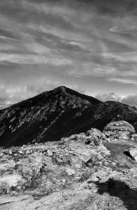
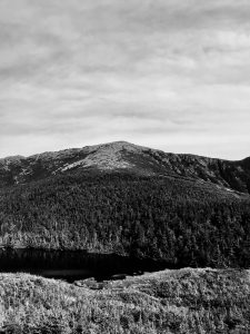
Mount Lafayette—also referred to as “Great Haystack”—is located in a section of the White Mountains referred to as the Franconia Range. With an elevation of roughly 5,249 feet (1,600 m), Lafayette is the tallest mountain in the Franconia sub-range of the White Mountains.
After descending Mount Washington on 12 July 1858, Thoreau, Edward Hoar, and Harrison Gray Otis Blake began their journey towards Franconia Notch and Lafayette on 13 July. The following day the three had made it to Lafayette and set up their camp about a half-mile up the mountain. On 15 July they reached Lafayette’s summit and soon after began to make the journey home, returning to Concord, MA 19 July—the trip lasting roughly three weeks in total.
Having visited the White Mountains in 1839 with his brother John Thoreau Jr., Thoreau’s return trip in 1858 lacked the expected nostalgia and instead was heavily focused on collecting and describing native flora. Thoreau even opted to descend Lafayette via the less-scenic bridle path—no longer as interested in the mountain’s views, but rather the species of birds that inhabited it.
Upon his arrival home on 19 July, Thoreau writes in his journal a detailed list of the supplies needed for an extended trip through the White Mountains:
Three strong check shirts.
Two pairs socks.
Neck ribbon and handkerchief.
Three pocket-handkerchiefs.
One thick waistcoat.
One thin (or half-thick) coat.
One thick coat (for mountain).
A large, broad india-rubber knapsack, with a broad flap . . .(Journal, 11:55-6).